I recently had the opportunity to visit the National Weather Service (NWS) station in Marquette, Michigan where I was greeted by the station manager, Robin Turner, KC8TII. Robin is a veteran weather service employee and master meteorologist. Bill Dowe, KC8EWD, the local SKYWARN manager and president of WX8MQT, joined Robin and me on a comprehensive tour of the facility.
Marquette, Michigan is a town that was founded in the 19th century along the southern coast of Lake Superior in Michigan's Upper Peninsula. Situated at roughly the midpoint along the southern coast of the lake, it has been an important location for Great Lakes shipping and commerce. The location is also just about perfect for locating a high level weather radar that can see not only most of Michigan's upper peninsula but 90% of the lake as well. This combination of attributes is why the National Weather Service chose the site to locate one of its powerful WSR-88D radar systems.
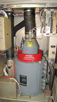
The NEXRAD WSR-88D is a 750 kilowatt, 10cm Doppler radar that can plot weather phenomena out to a 285 mile radius, which works out to more than a quarter million square miles of coverage. The radar can map both wind direction and precipitation and thus is capable of identifying many types of significant weather.
 | |
| The 750 KW Power Tube |
The data received by the dish is processed by an impressive array of weather modeling computers. These systems produce three dimensional models of the weather picture and can accurately predict significant weather such as severe thunderstorms and tornadoes.
Despite the remarkable ability of the WSR-88D, it is no substitute for a pair of human eyes observing actual weather conditions on the ground. It is for this reason that the most accurate and up-to-date information distributed by the NWS comes from direct observation, i.e., witnesses and observers who report what they see at the time.
One of the most valuable sources of real-time observations is the SKYWARN program, which consists of volunteers and amateur radio operators who have received basic training in weather observation. The training is given by the NWS and takes about two hours.
There are 122 local Weather Forecast offices across the country and each one has an designated SKYWARN coordinator that interfaces with local hams. Most of these locations also have ham radio equipment ready and standing by for immediate use. These sites typically have both HF and VHF capabilities using commercial, off-the-shelf, amateur radio gear that is provided by the federal government.
 |
| The WX8MQT HF/2M Station |
According to Bill, KC8EWD, the number one resource that SKYWARN depends on are the reports received from local hams. Sadly, it is not uncommon for Bill to open a weather net on the local repeater to complete silence with no other stations checking in.
At the Marquette office, I saw an excellent 2 meter / HF station with both a beam antenna as well as an inverted Vee dipole in operation. Bill informed me that SKYWARN participants were welcome to come and operate the station at any time, not only during severe weather conditions. Such operations helps to keep the equipment and its operators ready and able to spring into SKYWARN action when the need arises.
 |
| Dipole, HF Beam, and Radar! |
 |
| 3D Weather Graphic from Radar Data |
 |
| NWS Weather Station Console |
More photos of the site are available here...

I'd be interested to know what software they're using there at the console. I'm familiar with GEMPAK and IDV but that looks like something entirely different.
ReplyDelete